Naotkamegwanning First Nation
Naotkamegwanning First Nation
Jump to navigation
Jump to search
Naotkamegwanning First Nation, formerly known as Whitefish Bay First Nation and known in the Ojibwe language as Ne-adikamegwaning (Of the Whitefish Point), is an Ojibwa or Ontario Saulteaux First Nation located in Kenora District, Ontario near Sioux Narrows of Lake of the Woods.
Total registered population in September, 2010, was 1177, of which the on-reserve population was 713. The First Nation is a member of the Bimose Tribal Council, a regional tribal council that is a member of the Grand Council of Treaty 3.
Governance[edit]
Naotkamegwanning First Nation is currently governed by Chief Howard Kabestra and 4 Councillors: Melanie Copenace, Howard Kabestra, Delores Medicine, and Garnet Namaypoke. Their two-year term of offices expires November 15, 2015.
Reserves[edit]

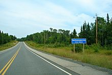
Whitefish Bay 32A reserve along Ontario Highway 71
The First Nation have reserved for themselves four reserves:
- 1954.3 ha Whitefish Bay 32A Indian Reserve, which serves as their main Reserve
- 1802.5 ha Yellow Girl Bay 32B Indian Reserve
- 518 ha Sabaskong Bay 32C Indian Reserve
- 379 ha Agency 30 Indian Reserve, which is shared with 12 other First Nations.
External links[edit]
- Naotkamegwanning First Nation Website
- AANDC Profile
.mw-parser-output .navbox-canada .navbox-title,.mw-parser-output .navbox-canada th,.mw-parser-output .navbox-canada .navbox-group,.mw-parser-output .navbox-canada .navbox-abovebelow,.mw-parser-output .navbox-canada .navbox-subgroup,.mw-parser-output .navbox-canada .navbox-odd,.mw-parser-output .navbox-canada .navbox-evenbackground-color:white.mw-parser-output .navbox-canada .navbox-list .collapsible .navbox-titlebox-shadow:inset 1px 1px 0 #C00,inset -1px -1px 0 #C00.mw-parser-output .navbox-canada-abox-shadow:inset 1px 1px 0 #C00,inset -1px -1px 0 #C00.mw-parser-output .navbox-canada-tbox-shadow:inset 0 1px 0 0 #C00.mw-parser-output .navbox-canada-bbox-shadow:inset 0 -1px 0 0 #C00.mw-parser-output .navbox-canada-tbbox-shadow:inset 0 1px 0 0 #C00,inset 0 -1px 0 0 #C00
Coordinates: 49°24′14″N 93°53′35″W / 49.40389°N 93.89306°W / 49.40389; -93.89306
This First Nations-related article is a stub. You can help Wikipedia by expanding it. |
This Northern Ontario geographical article is a stub. You can help Wikipedia by expanding it. |
Categories:
- First Nations governments in Ontario
- Saulteaux
- First Nations stubs
- Northern Ontario geography stubs
(window.RLQ=window.RLQ||).push(function()mw.config.set("wgPageParseReport":"limitreport":"cputime":"0.180","walltime":"0.227","ppvisitednodes":"value":605,"limit":1000000,"ppgeneratednodes":"value":0,"limit":1500000,"postexpandincludesize":"value":64494,"limit":2097152,"templateargumentsize":"value":72,"limit":2097152,"expansiondepth":"value":21,"limit":40,"expensivefunctioncount":"value":0,"limit":500,"unstrip-depth":"value":0,"limit":20,"unstrip-size":"value":894,"limit":5000000,"entityaccesscount":"value":1,"limit":400,"timingprofile":["100.00% 125.605 1 -total"," 50.11% 62.946 1 Template:Numbertreaty"," 46.41% 58.294 1 Template:Navbox_Canada"," 22.42% 28.160 1 Template:Coord"," 11.21% 14.074 2 Template:Cardinal_to_word"," 10.31% 12.955 2 Template:Asbox"," 10.23% 12.847 1 Template:FirstNations-stub"," 9.39% 11.797 2 Template:Navbox"," 8.88% 11.151 2 Template:Cardinal_to_word/0_to_999999"," 8.17% 10.259 1 Template:Grand_Council_of_Treaty_3"],"scribunto":"limitreport-timeusage":"value":"0.054","limit":"10.000","limitreport-memusage":"value":1207635,"limit":52428800,"cachereport":"origin":"mw1289","timestamp":"20181023235913","ttl":1900800,"transientcontent":false);mw.config.set("wgBackendResponseTime":76,"wgHostname":"mw1239"););


 Clash Royale CLAN TAG