File:Interstate Highway plan June 27, 1958.jpg
File:Interstate Highway plan June 27, 1958.jpg
Jump to navigation
Jump to search
- File
- File history
- File usage on Commons
- File usage on other wikis
Size of this preview: 800 × 579 pixels. Other resolutions: 320 × 232 pixels | 640 × 463 pixels | 1,024 × 741 pixels | 1,280 × 926 pixels | 1,520 × 1,100 pixels.
Original file (1,520 × 1,100 pixels, file size: 224 KB, MIME type: image/jpeg)
Public domainPublic domainfalsefalse |
This work is in the public domain in the United States because it was published in the United States between 1923 and 1977 without a copyright notice. See Commons:Hirtle chart for further explanation. Note that it may still be copyrighted in jurisdictions that do not apply the rule of the shorter term for US works (depending on the date of the author's death), such as Canada (50 p.m.a.), Mainland China (50 p.m.a., not Hong Kong or Macao), Germany (70 p.m.a.), Mexico (100 p.m.a.), Switzerland (70 p.m.a.), and other countries with individual treaties. |
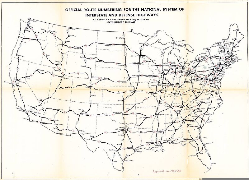
Interstate Highway plan approved June 27, 1958. Originally scanned by Richard Moeur and downloaded from [1]. Base map is from the FHWA with route numbers added by AASHTO. Map published without copyright notice and not registered/renewed in [2].
| Interstate Highway System planning maps | ||
|---|---|---|
| October 17, 1957: map 1 - map 2 - map 3 | June 27, 1958 | Ca. 1963 |
File history
Click on a date/time to view the file as it appeared at that time.
| Date/Time | Thumbnail | Dimensions | User | Comment | |
|---|---|---|---|---|---|
| current | 18:50, 14 December 2005 |  | 1,520 × 1,100 (224 KB) | SPUI~commonswiki (talk | contribs) | PD-USGov Interstate Highway plan approved June 27, 1958. Originally scanned by Richard Moeur and downloaded from [http://www.roadfan.com/jun58int.jpg]. Category:Interstate Highways Category:road maps |
- You cannot overwrite this file.
File usage on Commons
There are no pages that use this file.
File usage on other wikis
The following other wikis use this file:
- Usage on en.wikipedia.org
- List of suffixed Interstate Highways
- List of highways bypassed by Interstate Highways
- Usage on es.wikipedia.org
- Anexo:Autopistas Interestatales por sufijo
Category:
- Road maps of Interstate Highways
(window.RLQ=window.RLQ||).push(function()mw.config.set("wgPageParseReport":"limitreport":"cputime":"0.032","walltime":"0.053","ppvisitednodes":"value":169,"limit":1000000,"ppgeneratednodes":"value":0,"limit":1500000,"postexpandincludesize":"value":14528,"limit":2097152,"templateargumentsize":"value":1548,"limit":2097152,"expansiondepth":"value":14,"limit":40,"expensivefunctioncount":"value":1,"limit":500,"unstrip-depth":"value":0,"limit":20,"unstrip-size":"value":0,"limit":5000000,"entityaccesscount":"value":0,"limit":400,"timingprofile":["100.00% 38.516 1 Template:PD-Pre1978","100.00% 38.516 1 -total"," 81.68% 31.460 1 Template:Autotranslate"," 37.43% 14.417 1 Template:PD-US-no_notice/layout"," 14.44% 5.562 1 Template:PD-US-no_notice/lang"," 11.54% 4.446 1 Template:PD-Layout"," 11.19% 4.311 1 Template:Ifimage"," 7.80% 3.005 1 Template:Lang"," 4.68% 1.802 2 Template:Dir"," 4.52% 1.741 1 Template:Max"],"scribunto":"limitreport-timeusage":"value":"0.012","limit":"10.000","limitreport-memusage":"value":562507,"limit":52428800,"cachereport":"origin":"mw2229","timestamp":"20180926141537","ttl":86400,"transientcontent":true);mw.config.set("wgBackendResponseTime":100,"wgHostname":"mw2178"););