Thaumasia quadrangle
Thaumasia quadrangle
Jump to navigation
Jump to search
 Map of Thaumasia quadrangle from Mars Orbiter Laser Altimeter (MOLA) data. The highest elevations are red and the lowest are blue. | |
| Coordinates | 47°30′S 90°00′W / 47.5°S 90°W / -47.5; -90Coordinates: 47°30′S 90°00′W / 47.5°S 90°W / -47.5; -90 |
|---|---|

Image of the Thaumasia Quadrangle (MC-25). The northern part includes Thaumasia plateau. The southern part contains heavily cratered highland terrain and relatively smooth, low plains, such as Aonia Planum and Icaria Planum. Parts of Solis Planum, Aonia Terra, and Bosporus Planum are also found in this quadrangle. The east-central part includes Lowell Crater.
The Thaumasia quadrangle is one of a series of 30 quadrangle maps of Mars used by the United States Geological Survey (USGS) Astrogeology Research Program. The Thaumasia quadrangle is also referred to as MC-25 (Mars Chart-25).[1]
The name comes from Thaumas, the god of the clouds and celestial apparitions.[2]
The Thaumasia quadrangle covers the area from 60° to 120° west longitude and 30° to 65° south latitude on Mars. The Thaumasia quadrangle contains many different regions or parts of many regions: Solis Planum, Icaria Planum, Aonia Terra, Aonia Planum, Bosporus Planum, and Thaumasia Planum.[3] One of the first major networks of stream channels, called Warrego Valles, were discovered here by early orbiters. Another sign of water is the presence of gullies carved into steep slopes.
Contents
1 Martian Gullies
2 Sand Dunes
3 Warrego Valles
4 Craters
5 Channels
6 Other views from Thaumasia
7 Other Mars quadrangles
8 Interactive Mars map
9 See also
10 References
11 Further reading
12 External links
Martian Gullies[edit]
Gullies are common in some parts of Mars. Gullies occur on steep slopes, especially on the walls of craters. Martian gullies are believed to be relatively young because they have few, if any craters. Moreover, they lie on top of sand dunes which themselves are considered to be quite young. Usually, each gully has an alcove, channel, and apron. Some studies have found that gullies occur on slopes that face all directions,[4] others have found that the greater number of gullies are found on poleward facing slopes, especially from 30-44 S.[5][6]
Although many ideas have been put forward to explain them,[7] the most popular involve liquid water coming from an aquifer, from melting at the base of old glaciers, or from the melting of ice in the ground when the climate was warmer.[8][9] Because of the good possibility that liquid water was involved with their formation and that they could be very young, scientists are excited. Maybe the gullies are where we should go to find life.
There is evidence for all three theories. Most of the gully alcove heads occur at the same level, just as one would expect of an aquifer. Various measurements and calculations show that liquid water could exist in aquifers at the usual depths where gullies begin.[10] One variation of this model is that rising hot magma could have melted ice in the ground and caused water to flow in aquifers. Aquifers are layer that allow water to flow. They may consist of porous sandstone. The aquifer layer would be perched on top of another layer that prevents water from going down (in geological terms it would be called impermeable). Because water in an aquifer is prevented from going down, the only direction the trapped water can flow is horizontally. Eventually, water could flow out onto the surface when the aquifer reaches a break—like a crater wall. The resulting flow of water could erode the wall to create gullies.[11] Aquifers are quite common on Earth. A good example is "Weeping Rock" in Zion National Park Utah.[12]
As for the next theory, much of the surface of Mars is covered by a thick smooth mantle that is thought to be a mixture of ice and dust.[13][14][15] This ice-rich mantle, a few yards thick, smoothes the land, but in places it has a bumpy texture, resembling the surface of a basketball. The mantle may be like a glacier and under certain conditions the ice that is mixed in the mantle could melt and flow down the slopes and make gullies.[16][17][18] Because there are few craters on this mantle, the mantle is relatively young. An excellent view of this mantle is shown below in the picture of the Ptolemaeus Crater Rim, as seen by HiRISE.[19]
The ice-rich mantle may be the result of climate changes.[20] Changes in Mars's orbit and tilt cause significant changes in the distribution of water ice from polar regions down to latitudes equivalent to Texas. During certain climate periods water vapor leaves polar ice and enters the atmosphere. The water comes back to ground at lower latitudes as deposits of frost or snow mixed generously with dust. The atmosphere of Mars contains a great deal of fine dust particles. Water vapor will condense on the particles, then fall down to the ground due to the additional weight of the water coating. When Mars is at its greatest tilt or obliquity, up to 2 cm of ice could be removed from the summer ice cap and deposited at midlatitudes. This movement of water could last for several thousand years and create a snow layer of up to around 10 meters thick.[21][22] When ice at the top of the mantling layer goes back into the atmosphere, it leaves behind dust, which insulating the remaining ice.[23] Measurements of altitudes and slopes of gullies support the idea that snowpacks or glaciers are associated with gullies. Steeper slopes have more shade which would preserve snow.[5][24]
Higher elevations have far fewer gullies because ice would tend to sublimate more in the thin air of the higher altitude.[25] Very few gullies are found in the Thaumasia region; however, a few are present in the lower elevations like the one pictured below in Ross Crater.
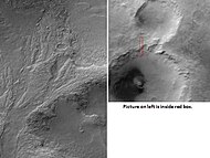
CTX image of part of Ross Crater showing context for next image from HiRISE.
Gullies in Ross Crater, as seen by HiRISE under the HiWish program. Because the gullies are on the narrow rim of a crater and they start at different heights, this example is not consistent with the model of gullies being caused by aquifers.

Group of gullies in Ross Crater, as seen by HiRISE under HiWish program
Close-up of gullies showing multiple channels, as seen by HiRISE under HiWish program Note: this is an enlargement of a previous image.
Close-up of gullies showing polygons, as seen by HiRISE under HiWish program Polygons usually form in frozen ice-rich ground. Note: this is an enlargement of a previous image.

Close-up of gullies showing streamlined forms in channels, as seen by HiRISE under HiWish program Note: this is an enlargement of a previous image.
Wide view of gullies in Ross Crater, as seen by HiRISE under HiWish program

Close view of many small gullies in Ross Crater, as seen by HiRISE under HiWish program Note: this is an enlargement of a previous image.

Close view of polygons near gullies in Ross Crater, as seen by HiRISE under HiWish program Note: this is an enlargement of a previous image.

Close view of polygons near gullies in Ross Crater, as seen by HiRISE under HiWish program Note: this is an enlargement of a previous image.

Gullies, as seen by HiRISE under HiWish program

Group of gullies, as seen by HiRISE under the HiWish program

Enlargement of part of previous image showing smaller gullies inside larger ones. Water probably flowed in these gullies more than once.

Gullies, as seen by HiRISE under the HiWish program


The third theory might be possible since climate changes may be enough to simply allow ice in the ground to melt and thus form the gullies. During a warmer climate, the first few meters of ground could thaw and produce a "debris flow" similar to those on the dry and cold Greenland east coast.[26] Since the gullies occur on steep slopes only a small decrease of the shear strength of the soil particles is needed to begin the flow. Small amounts of liquid water from melted ground ice could be enough.[27][28] Calculations show that a third of a mm of runoff can be produced each day for 50 days of each Martian year, even under current conditions.[29]
Sand Dunes[edit]
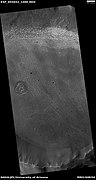
Many places on Mars have sand dunes. Some craters in Thaumasia show dark blotches in them. High resolution photos show that the dark markings are dark sand dunes. Dark sand dunes probably contain the igneous rock basalt.[30]Brashear Crater, pictured below, is one crater with dark dunes.
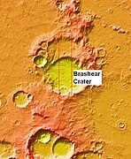
Wide view of Brashear (Martian Crater) near other craters, as seen by MOLA in which elevations are indicated by different colors.

Mars Global Surveyor context image with box showing where next image is located.

Mars Global Surveyor image of part of area in the previous photo. The dark spots are resolved to be sand dunes. Image taken under the MOC Public Targeting Program.

Crater floor covered with sand dunes in the shape of cells, as seen by HiRISE under HiWish program.


Warrego Valles[edit]
Mariner 9 and Viking Orbiter images, showed a network of branching valleys in Thaumasia called Warrego Valles. These networks are evidence that Mars may have once been warmer, wetter, and perhaps had precipitation in the form of rain or snow. A study with the Mars Orbiter Laser Altimeter, Thermal Emission Imaging System (THEMIS) and the Mars Orbiter Camera (MOC) support the idea that Warrego Valles was formed from precipitation.[31] At first glance they resemble river valleys on our Earth. But sharper images from more advanced cameras reveal that the valleys are not continuous. They are very old and may have suffered from the effects of erosion. A picture below shows some of these branching valleys.[32]

Channels near Warrego Valles, as seen by THEMIS. These branched channels are strong evidence for flowing water on Mars, perhaps during a much warmer period.

Craters[edit]
The density of impact craters is used to determine the surface ages of Mars and other solar system bodies.[33] The older the surface, the more craters present. Crater shapes can reveal the presence of ground ice.
The area around craters may be rich in minerals. On Mars, heat from the impact melts ice in the ground. Water from the melting ice dissolves minerals, and then deposits them in cracks or faults that were produced with the impact. This process, called hydrothermal alteration, is a major way in which ore deposits are produced. The area around Martian craters may be rich in useful ores for the future colonization of Mars.[34]
Studies on the earth have documented that cracks are produced and that secondary minerals veins are deposited in the cracks.[35][36][37] Images from satellites orbiting Mars have detected cracks near impact craters.[38] Great amounts of heat are produced during impacts. The area around a large impact may take hundreds of thousands of years to cool.[39][40][41]
Many craters once contained lakes.[42][43][44] Because some crater floors show deltas, we know that water had to be present for some time. Dozens of deltas have been spotted on Mars.[45] Deltas form when sediment is washed in from a stream entering a quiet body of water. It takes a bit of time to form a delta, so the presence of a delta is exciting; it means water was there for a time, maybe for many years. Primitive organisms may have developed in such lakes; hence, some craters may be prime targets for the search for evidence of life on the Red Planet.[46]

Unnamed rater with thin ejecta, as seen by HiRISE under the HiWish program There are also many cones visible in the image.

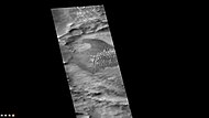
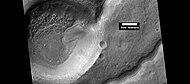
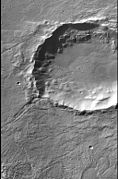
East side of Douglass Crater, as seen by CTX camera (on Mars Reconnaissance Orbiter)
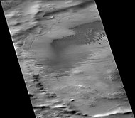
Lamont Crater, as seen by CTX camera (on Mars Reconnaissance Orbiter). Dark areas are composed of mostly dunes.

Dunes on floor of Lamont Crater, as seen by CTX camera (on Mars Reconnaissance Orbiter). Note: this is an enlargement of the previous image.

Coblentz Crater, as seen by CTX camera (on Mars Reconnaissance Orbiter).
Biachini Crater, as seen by CTX camera (on Mars Reconnaissance Orbiter). Dust devil tracks and dunes are visible on the floor. The narrow, dark lines are dust devil tracks.

Fontana Crater, as seen by CTX camera (on Mars Reconnaissance Orbiter).

Dust devil tracks just outside north rim of Fontana Crater, as seen by CTX camera (on Mars Reconnaissance Orbiter). Note: this is an enlargement of the previous image of Fontana Crater.

Lampland Crater (Martian Crater), as seen by CTX camera (on Mars Reconnaissance Orbiter).

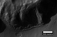
Layers in wall of Lampland Crater, as seen by CTX camera (on Mars Reconnaissance Orbiter). Note: this is an enlargement of the previous image of Lampland Crater.

Slipher Crater (Martian Crater), as seen by CTX camera (on Mars Reconnaissance Orbiter).

Gullies in crater on the rim of Slipher Crater, as seen by CTX camera (on Mars Reconnaissance Orbiter). Note: this is an enlargement of the previous image of Slipher Crater.

Mantle layers exposed on crater rim, as seen by HiRISE under HiWish program Mantle is an ice-rich material that fell from the sky when the climate underwent major changes.

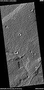
Pointed crater, as seen by HiRISE under HiWish program Impacting object may have struck at a low angle.


Wide view of crater floor, as seen by HiRISE under HiWish program Some depressions on the floor have a mound in the center.

Close view of a mound in a depression, as seen by HiRISE under HiWish program
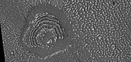
Concentric ridges on crater floor, as seen by HiRISE under HiWish program


Channels[edit]
There is enormous evidence that water once flowed in river valleys on Mars.[47][48] Images of curved channels have been seen in images from Mars spacecraft dating back to the early seventies with the Mariner 9 orbiter.[49][50][51][52] Indeed, a study published in June 2017, calculated that the volume of water needed to carve all the channels on Mars was even larger than the proposed ocean that the planet may have had. Water was probably recycled many times from the ocean to rainfall around Mars.[53][54]

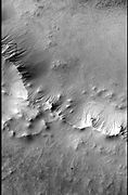
Branched channels in Thaumasia quadrangle, as seen by Viking Orbiter. Networks of channels like this are strong evidence for rain on Mars in the past.
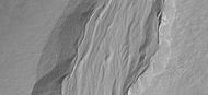
Crater and one of many nearby channels, as seen by HiRISE under HiWish program Picture is from Icaria Planum.

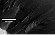
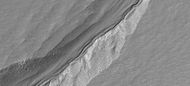
Channel, as seen by HiRISE under HiWish program

Channel, as seen by HiRISE under HiWish program
Channel, as seen by HiRISE under HiWish program


Other views from Thaumasia[edit]

Map of Thaumasia quadrangle with major craters labeled. Lowell Crater is named after Percival Lowell.
Lowell Crater Northeast Rim, as seen by HiRISE. Crater floor is toward the bottom of picture.
CTX image from Icaria Planum that shows location of next image.
Layers in mantle deposit, as seen by HiRISE, under the HiWish program. Mantle was probably formed from snow and dust falling during a different climate.

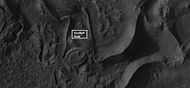
Possible dike in Thaumasia, as seen by HiRISE under HiWish program. Dikes may have deposited valuable minerals.

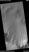
Signs of material moving down the side of a ridge, as seen by HiRISE, under the HiWish program.
Strange surface features, as seen by HiWish under the HiWish program.
Porter Crater rim, as seen with Mars Global Surveyor.

Curved ridge that probably was formed by glacier, as seen by HiRISE under HiWish program

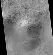
Brain terrain, as seen by HiRISE under HiWish program Box shows the size of football field.

Cracks and pits that form square shapes, as seen by HiRISE under HiWish program Arrow points to squares formed by cracks.

Ridges, as seen by HiRISE under HiWish program