Ceylanpınar
Ceylanpınar
Jump to navigation
Jump to search
| Ceylanpınar | |
|---|---|
 Ceylanpınar | |
Coordinates: 36°50′46″N 40°02′56″E / 36.84611°N 40.04889°E / 36.84611; 40.04889Coordinates: 36°50′46″N 40°02′56″E / 36.84611°N 40.04889°E / 36.84611; 40.04889 | |
| Country | |
| Province | Şanlıurfa |
| Government | |
| • Mayor | Menderes Atilla (AKP) |
| • Kaymakam | Musa Uslan |
| Area[1] | |
| • District | 2,200.84 km2 (849.75 sq mi) |
| Population (2012)[2] | |
| • Urban | 48,050 |
| • District | 77,981 |
| • District density | 35/km2 (92/sq mi) |
| Post code | 63570 |
| Website | www.ceylanpinar.bel.tr |
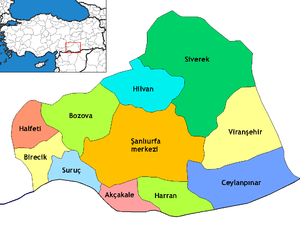
Districts of Şanlıurfa
Ceylanpınar (Arabic: رأس العين Ra's al 'Ayn, Kurdish: Serêkanî, Ottoman Turkish: رأس العين Resülayn[3]) is a district of Şanlıurfa Province in southeastern Turkey. On the border with Syria, it is reached by a long straight road ![]() across the plain south from Viranşehir. It forms a divided city with Ra's al-'Ayn in Syria and there is a border crossing.
across the plain south from Viranşehir. It forms a divided city with Ra's al-'Ayn in Syria and there is a border crossing.
The district covers an area of 2,003 km2 (773 sq mi) and has a population of 69,774 (2000 census), of whom 44,258 live in the town of Ceylanpınar itself.[4]
Immigration[edit]
Evren Paşa neighborhood is populated by Uzbeks which came from Afghanistan as refugees.[5]
Climate[edit]
Ceylanpınar has a semi-arid climate. Summers are extremely hot with virtually no rain at all, winters tend to be cool but can become very cold due to northeasterly winds. The Köppen Climate Classification subtype for this climate is "Csa" (Mediterranean Climate).[6]
| Climate data for Ceylanpınar | |||||||||||||
|---|---|---|---|---|---|---|---|---|---|---|---|---|---|
| Month | Jan | Feb | Mar | Apr | May | Jun | Jul | Aug | Sep | Oct | Nov | Dec | Year |
| Average high °C (°F) | 11 (52) | 13 (55) | 18 (64) | 23 (73) | 30 (86) | 37 (99) | 40 (104) | 40 (104) | 36 (97) | 28 (82) | 20 (68) | 13 (55) | 26 (78) |
| Average low °C (°F) | 0 (32) | 1 (34) | 4 (39) | 8 (46) | 12 (54) | 17 (63) | 20 (68) | 19 (66) | 15 (59) | 10 (50) | 4 (39) | 1 (34) | 9 (49) |
| Average precipitation mm (inches) | 70 (2.76) | 66 (2.6) | 62 (2.44) | 44 (1.73) | 22 (0.87) | 0 (0) | 0 (0) | 0 (0) | 0 (0) | 22 (0.87) | 44 (1.73) | 69 (2.72) | 399 (15.72) |
| Average precipitation days | 12 | 11 | 11 | 10 | 7 | 0 | 0 | 0 | 0 | 5 | 9 | 11 | 76 |
| Source: Weatherbase [7] | |||||||||||||
References[edit]
^ "Area of regions (including lakes), km²". Regional Statistics Database. Turkish Statistical Institute. 2002. Retrieved 2013-03-05..mw-parser-output cite.citationfont-style:inherit.mw-parser-output qquotes:"""""""'""'".mw-parser-output code.cs1-codecolor:inherit;background:inherit;border:inherit;padding:inherit.mw-parser-output .cs1-lock-free abackground:url("//upload.wikimedia.org/wikipedia/commons/thumb/6/65/Lock-green.svg/9px-Lock-green.svg.png")no-repeat;background-position:right .1em center.mw-parser-output .cs1-lock-limited a,.mw-parser-output .cs1-lock-registration abackground:url("//upload.wikimedia.org/wikipedia/commons/thumb/d/d6/Lock-gray-alt-2.svg/9px-Lock-gray-alt-2.svg.png")no-repeat;background-position:right .1em center.mw-parser-output .cs1-lock-subscription abackground:url("//upload.wikimedia.org/wikipedia/commons/thumb/a/aa/Lock-red-alt-2.svg/9px-Lock-red-alt-2.svg.png")no-repeat;background-position:right .1em center.mw-parser-output .cs1-subscription,.mw-parser-output .cs1-registrationcolor:#555.mw-parser-output .cs1-subscription span,.mw-parser-output .cs1-registration spanborder-bottom:1px dotted;cursor:help.mw-parser-output .cs1-hidden-errordisplay:none;font-size:100%.mw-parser-output .cs1-visible-errorfont-size:100%.mw-parser-output .cs1-subscription,.mw-parser-output .cs1-registration,.mw-parser-output .cs1-formatfont-size:95%.mw-parser-output .cs1-kern-left,.mw-parser-output .cs1-kern-wl-leftpadding-left:0.2em.mw-parser-output .cs1-kern-right,.mw-parser-output .cs1-kern-wl-rightpadding-right:0.2em
^ "Population of province/district centers and towns/villages by districts - 2012". Address Based Population Registration System (ABPRS) Database. Turkish Statistical Institute. Retrieved 2013-02-27.
^ Tahir Sezen, Osmanlı Yer Adları (Alfabetik Sırayla), T.C. Başbakanlık Devlet Arşivleri Genel Müdürlüğü, Yayın Nu 21, Ankara, p. 419.
^ GABB - Ceylanpınar Belediyesi Archived September 28, 2007, at the Wayback Machine.
^ [1] Urfa'daki Özbek Türkleri Nevruz'u kutladı
^ Climate Summary
^ http://www.weatherbase.com/weather/weather.php3?s=172751&refer=&cityname=Ceylanpinar-H'ims-Syria&units=metric
Ceylanpınar in Şanlıurfa Province of Turkey | |||||||||||||||||||||||||||
|---|---|---|---|---|---|---|---|---|---|---|---|---|---|---|---|---|---|---|---|---|---|---|---|---|---|---|---|
| Districts |
|  | |||||||||||||||||||||||||
||
Metropolitan municipalities are bolded. | |||||||||||||||||||||||||||
Bulgaria |
|
|---|---|
Greece |
|
Syria |
|
Iraq |
|
Iran |
|
Nakhchivan (Azerbaijan) |
|
Armenia |
|
Georgia |
|
This article about a Southeastern Anatolia Region of Turkey location is a stub. You can help Wikipedia by expanding it. |
Categories:
- Şanlıurfa
- Syria–Turkey border crossings
- Populated places in Şanlıurfa Province
- Divided cities on the Turkish-Syrian border
- Districts of Şanlıurfa Province
- Southeastern Anatolia Region geography stubs
(window.RLQ=window.RLQ||).push(function()mw.config.set("wgPageParseReport":"limitreport":"cputime":"0.896","walltime":"1.046","ppvisitednodes":"value":5824,"limit":1000000,"ppgeneratednodes":"value":0,"limit":1500000,"postexpandincludesize":"value":110857,"limit":2097152,"templateargumentsize":"value":11901,"limit":2097152,"expansiondepth":"value":25,"limit":40,"expensivefunctioncount":"value":2,"limit":500,"unstrip-depth":"value":1,"limit":20,"unstrip-size":"value":8006,"limit":5000000,"entityaccesscount":"value":1,"limit":400,"timingprofile":["100.00% 908.495 1 -total"," 64.41% 585.151 1 Template:Infobox_settlement"," 53.23% 483.599 1 Template:Infobox"," 13.52% 122.859 1 Template:Lang-ar"," 10.38% 94.346 2 Template:Turkey_district_areas"," 9.90% 89.984 4 Template:Turkey_district_populations"," 8.21% 74.631 2 Template:Cite_web"," 7.38% 67.080 1 Template:Weather_box"," 5.80% 52.703 3 Template:Navbox"," 5.22% 47.430 1 Template:Short_description"],"scribunto":"limitreport-timeusage":"value":"0.421","limit":"10.000","limitreport-memusage":"value":12087726,"limit":52428800,"cachereport":"origin":"mw2275","timestamp":"20181001020531","ttl":1900800,"transientcontent":false);mw.config.set("wgBackendResponseTime":80,"wgHostname":"mw2232"););

 Clash Royale CLAN TAG