Edward River Council
Edward River Council
Jump to navigation
Jump to search
Edward River Council New South Wales | |||||||||||||||
|---|---|---|---|---|---|---|---|---|---|---|---|---|---|---|---|
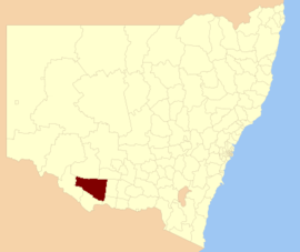
 Location in New South Wales | |||||||||||||||
| Coordinates | 35°32′S 144°58′E / 35.533°S 144.967°E / -35.533; 144.967Coordinates: 35°32′S 144°58′E / 35.533°S 144.967°E / -35.533; 144.967 | ||||||||||||||
| Population | 8,851 (2016 census)[1] | ||||||||||||||
| • Density | 0.99662/km2 (2.58124/sq mi) | ||||||||||||||
| Established | 2016 | ||||||||||||||
| Area | 8,881 km2 (3,429.0 sq mi) | ||||||||||||||
| Mayor | Norm Brennan | ||||||||||||||
| Council seat | Deniliquin | ||||||||||||||
| Region | Riverina | ||||||||||||||
| State electorate(s) | Murray | ||||||||||||||
| Federal Division(s) | Farrer | ||||||||||||||
 | |||||||||||||||
| Website | Edward River Council | ||||||||||||||
| |||||||||||||||
The Edward River Council is a local government area in the Riverina region of New South Wales, Australia. This area was formed in 2016 from the merger of the Deniliquin Council with the surrounding Conargo Shire.[2]
The combined area covers the urban area of Deniliquin and the surrounding region to the north and west across the pastoral southern Riverina plains.
The inaugural Mayor of the Edward River Council is Norm Brennan, elected by the Councillors on 20 September 2017.
Contents
1 Main towns and villages
2 Demographics
3 Council
4 See also
5 References
Main towns and villages[edit]
In addition to the main centre of Deniliquin, localities in the area include Blighty, Booroorban, Conargo, Mayrung, Morago, Pretty Pine and Wanganella.
Demographics[edit]
This section is empty. You can help by adding to it. (May 2016) |
Council[edit]
Edward River Council has nine Councillors elected proportionally as a single ward. All Councillors are elected for a fixed four-year term of office.[2]
The most recent election was held on 9 September 2017, and the makeup of the council is as follows:[3]
| Party | Councillors | |
|---|---|---|
| | Australian Labor Party | 0 |
| | Greens NSW | 0 |
| | Liberal Party of Australia | 0 |
| | Independents and unaligned | 9 |
Total | 9 | |
| Councillor | Party | Notes | |
|---|---|---|---|
| | Norm Brennan | Independent | Mayor Former councillor of Conargo Shire |
| | Pat Fogarty | Independent | Former councillor of Deniliquin Council |
| | Ashley Hall | Independent | Former Mayor of Deniliquin Council, Administrator of Edward River Council 2016-17 |
| | Mac Wallace | Unaligned | Former councillor of Conargo Shire |
| | Norm McAllister | Unaligned | Former councillor of Conargo Shire |
| | Margaret Bull | Independent | |
| | Peter McCrabb | Independent | Former councillor of Conargo Shire |
| | Peta Betts | Unaligned | |
| | Nick Metcalfe | Independent | Former councillor of Conargo Shire |
See also[edit]
- Local government areas of New South Wales
- Edward River Council Website
References[edit]
^ Australian Bureau of Statistics (27 June 2017). "Edward River (A)". 2016 Census QuickStats. Retrieved 8 December 2017..mw-parser-output cite.citationfont-style:inherit.mw-parser-output qquotes:"""""""'""'".mw-parser-output code.cs1-codecolor:inherit;background:inherit;border:inherit;padding:inherit.mw-parser-output .cs1-lock-free abackground:url("//upload.wikimedia.org/wikipedia/commons/thumb/6/65/Lock-green.svg/9px-Lock-green.svg.png")no-repeat;background-position:right .1em center.mw-parser-output .cs1-lock-limited a,.mw-parser-output .cs1-lock-registration abackground:url("//upload.wikimedia.org/wikipedia/commons/thumb/d/d6/Lock-gray-alt-2.svg/9px-Lock-gray-alt-2.svg.png")no-repeat;background-position:right .1em center.mw-parser-output .cs1-lock-subscription abackground:url("//upload.wikimedia.org/wikipedia/commons/thumb/a/aa/Lock-red-alt-2.svg/9px-Lock-red-alt-2.svg.png")no-repeat;background-position:right .1em center.mw-parser-output .cs1-subscription,.mw-parser-output .cs1-registrationcolor:#555.mw-parser-output .cs1-subscription span,.mw-parser-output .cs1-registration spanborder-bottom:1px dotted;cursor:help.mw-parser-output .cs1-hidden-errordisplay:none;font-size:100%.mw-parser-output .cs1-visible-errorfont-size:100%.mw-parser-output .cs1-subscription,.mw-parser-output .cs1-registration,.mw-parser-output .cs1-formatfont-size:95%.mw-parser-output .cs1-kern-left,.mw-parser-output .cs1-kern-wl-leftpadding-left:0.2em.mw-parser-output .cs1-kern-right,.mw-parser-output .cs1-kern-wl-rightpadding-right:0.2em
^ ab "Edward River Council". Stronger Councils. Government of New South Wales. 12 May 2016. Retrieved 13 May 2016.
^ "Edward River Council - Candidates in Sequence of Election". Local Government Elections 2017. NSW Electoral Commission. 14 September 2017. Retrieved 15 September 2017.
Categories:
- Populated places established in 2016
- 2016 establishments in Australia
- Local government areas of New South Wales
- Riverina
(window.RLQ=window.RLQ||).push(function()mw.config.set("wgPageParseReport":"limitreport":"cputime":"0.372","walltime":"0.483","ppvisitednodes":"value":4622,"limit":1000000,"ppgeneratednodes":"value":0,"limit":1500000,"postexpandincludesize":"value":104064,"limit":2097152,"templateargumentsize":"value":8434,"limit":2097152,"expansiondepth":"value":12,"limit":40,"expensivefunctioncount":"value":7,"limit":500,"unstrip-depth":"value":1,"limit":20,"unstrip-size":"value":8618,"limit":5000000,"entityaccesscount":"value":1,"limit":400,"timingprofile":["100.00% 355.192 1 -total"," 36.15% 128.414 1 Template:Infobox_Australian_place"," 25.12% 89.236 1 Template:Reflist"," 23.31% 82.781 1 Template:Infobox"," 19.51% 69.303 1 Template:Census_2016_AUS"," 18.84% 66.927 3 Template:Cite_web"," 8.92% 31.695 13 Template:Australian_party_style"," 8.18% 29.041 13 Template:Australian_politics/party_colours"," 8.01% 28.441 1 Template:Coord"," 7.91% 28.090 1 Template:Use_Australian_English"],"scribunto":"limitreport-timeusage":"value":"0.132","limit":"10.000","limitreport-memusage":"value":4536252,"limit":52428800,"cachereport":"origin":"mw1255","timestamp":"20181027033156","ttl":1900800,"transientcontent":false);mw.config.set("wgBackendResponseTime":99,"wgHostname":"mw1325"););

 Clash Royale CLAN TAG