Great Lakes Council
Great Lakes Council
Jump to navigation
Jump to search
Great Lakes Council New South Wales | |||||||||||||||
|---|---|---|---|---|---|---|---|---|---|---|---|---|---|---|---|
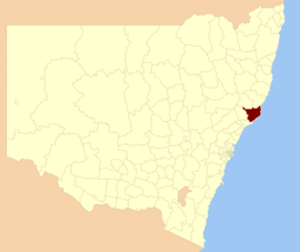 Location in New South Wales | |||||||||||||||
| Coordinates | 32°13′S 152°32′E / 32.217°S 152.533°E / -32.217; 152.533Coordinates: 32°13′S 152°32′E / 32.217°S 152.533°E / -32.217; 152.533 | ||||||||||||||
| Population | 34,430 (2011 census)[1] | ||||||||||||||
| • Density | 10.1985/km2 (26.414/sq mi) | ||||||||||||||
| Abolished | 12 May 2016 (2016-05-12) | ||||||||||||||
| Area | 3,376 km2 (1,303.5 sq mi) | ||||||||||||||
| Time zone | AEST (UTC+10) | ||||||||||||||
| • Summer (DST) | AEDT (UTC+11) | ||||||||||||||
| Mayor | Jan McWilliams[2] | ||||||||||||||
| Council seat | Forster | ||||||||||||||
| Region | Hunter[3] | ||||||||||||||
| State electorate(s) |
| ||||||||||||||
| Federal Division(s) | Paterson[7] | ||||||||||||||
| Website | Great Lakes Council | ||||||||||||||
| |||||||||||||||
Great Lakes Council was a local government area in the Mid North Coast region of New South Wales, Australia. The area is situated adjacent to the shores of Port Stephens, Myall Lakes and Wallis Lake and the Pacific Highway and the Lakes Way. On 12 May 2016 the Council was dissolved and the area included in the Mid-Coast Council, along with City of Greater Taree and Gloucester Shire.[8]
The Great Lakes area is home to the globally significant, Ramsar Convention listed Myall Lakes wetlands. These wetlands are an important foundation for the economies of the former suburbs of the Great Lakes Council local government area, particularly the recreational fisheries and tourism sectors.[citation needed]
Contents
1 Amalgamation
2 Demographics
3 Council
3.1 Former composition and election method
4 References
5 External links
Amalgamation[edit]
A 2015 review of local government boundaries by the NSW Government Independent Pricing and Regulatory Tribunal recommended the merger of a number of adjoining councils. In the initial proposal, the Great Lakes Council was not included in any amalgamation proposals. However, Gloucester Shire Council submitted an alternate proposal to amalgamate the Gloucester, Great Lakes and Greater Taree councils.[9] The outcome of an independent review was completed by May 2016, when the Council was dissolved.
Demographics[edit]
At the 2011 census, there were 34,430 people in the Great Lakes Council local government area, of these 49.0 per cent were male and 51.0 per cent were female. Aboriginal and Torres Strait Islander people made up 3.8 per cent of the population, which was higher than the national and state averages of 2.5 per cent. The median age of people in the Great Lakes Council area was 52 years, significantly higher than the national median of 37 years; and the highest median of any local government area in New South Wales. Children aged 0 – 14 years made up 15.4 per cent of the population; and people aged 65 years and over made up 30.6 per cent of the population, with the latter significantly influencing the median age. Of people in the area aged 15 years and over, 52.4 per cent were married and 15.0 per cent were either divorced or separated.[1]
Population growth in the Great Lakes Council between the 2001 census and the 2006 census was 4.00 per cent; and in the subsequent five years to the 2011 census, population growth was 5.08 per cent. When compared with total population growth of Australia for the same periods, being 5.78 per cent and 8.32 per cent respectively, population growth in the Great Lakes Council local government area was significantly lower than the national average.[10][11] The median weekly income for residents within the Great Lakes Council area was nearly half the national average.[1]
At the 2011 census, the proportion of residents in the Great Lakes Council local government area who stated their ancestry as Australian or Anglo-Saxon exceeded 82 per cent of all residents (national average was 65.2 per cent). In excess of 66% of all residents in the Great Lakes Council area nominated a religious affiliation with Christianity at the 2011 census, which was significantly higher than the national average of 50.2 per cent. Meanwhile, as at the census date, compared to the national average, households in the Great Lakes Council local government area had a significantly lower than average proportion (3.6 per cent) where two or more languages are spoken (national average was 20.4 per cent); and a significantly higher proportion (92.6 per cent) where English only was spoken at home (national average was 76.8 per cent).[1]
| Selected historical census data for the Great Lakes Council local government area | |||||
|---|---|---|---|---|---|
| Census year | 2001[10] | 2006[11] | 2011[1] | ||
| Population | Estimated residents on Census night | 31,266 | 32,766 | 34,430 | |
| LGA rank in terms of size within New South Wales | |||||
| % of New South Wales population | 0.50% | ||||
| % of Australian population | 0.17% | ||||
| Cultural and language diversity | |||||
Ancestry, top responses | English | 34.2% | |||
| Australian | 32.5% | ||||
| Irish | 8.6% | ||||
| Scottish | 7.6% | ||||
| German | 2.7% | ||||
| Language, top responses (other than English) | German | 0.1% | |||
| Italian | 0.2% | ||||
| Cantonese | 0.2% | ||||
| Dutch | 0.1% | ||||
| French | 0.1% | ||||
| Religious affiliation | |||||
Religious affiliation, top responses | Anglican | 38.1% | |||
| Catholic | 22.1% | ||||
| No Religion | 11.3% | ||||
| Uniting Church | 7.4% | ||||
| Presbyterian and Reformed | 4.5% | ||||
| Median weekly incomes | |||||
| Personal income | Median weekly personal income | A$338 | A$395 | ||
| % of Australian median income | 72.5% | ||||
| Family income | Median weekly family income | A$747 | A$881 | ||
| % of Australian median income | 63.8% | ||||
| Household income | Median weekly household income | A$611 | A$729 | ||
| % of Australian median income | 59.5% | ||||
Council[edit]
Former composition and election method[edit]
At the time of its dissolution, the Great Lakes Council was composed of nine Councillors elected proportionally as a single ward. All Councillors were elected for a fixed four-year term of office. The Mayor was elected by the Councillors at the first meeting of the Council. The most recent and last election was held on 8 September 2012 and the makeup of the Council was as follows:[12]
| Party | Councillors | |
|---|---|---|
| | Independents and Unaligned | 8 |
| | Labor Party | 1 |
Total | 9 | |
The lastt Council, elected in 2012 and dissolved in 2016, in order of election, was:[12]
| Councillor | Party | Notes | |
|---|---|---|---|
| | Jan McWilliams | Independent | Mayor |
| | Len Roberts | Unaligned | |
| | Karen Hutchinson | Independent | Elected on Jan McWilliams's ticket |
| | Tony Summers | Independent | |
| | Linda Gill | Independent | |
| | John Weate | Country Labor | |
| | Leigh Vaughan | Unaligned | |
| | Jim Morwitch | Independent | |
| | Carol McCaskie | Unaligned | Elected on Len Roberts's ticket |
References[edit]
^ abcde Australian Bureau of Statistics (31 October 2012). "Great Lakes (Local Government Area)". 2011 Census QuickStats. Retrieved 10 September 2012..mw-parser-output cite.citationfont-style:inherit.mw-parser-output qquotes:"""""""'""'".mw-parser-output code.cs1-codecolor:inherit;background:inherit;border:inherit;padding:inherit.mw-parser-output .cs1-lock-free abackground:url("//upload.wikimedia.org/wikipedia/commons/thumb/6/65/Lock-green.svg/9px-Lock-green.svg.png")no-repeat;background-position:right .1em center.mw-parser-output .cs1-lock-limited a,.mw-parser-output .cs1-lock-registration abackground:url("//upload.wikimedia.org/wikipedia/commons/thumb/d/d6/Lock-gray-alt-2.svg/9px-Lock-gray-alt-2.svg.png")no-repeat;background-position:right .1em center.mw-parser-output .cs1-lock-subscription abackground:url("//upload.wikimedia.org/wikipedia/commons/thumb/a/aa/Lock-red-alt-2.svg/9px-Lock-red-alt-2.svg.png")no-repeat;background-position:right .1em center.mw-parser-output .cs1-subscription,.mw-parser-output .cs1-registrationcolor:#555.mw-parser-output .cs1-subscription span,.mw-parser-output .cs1-registration spanborder-bottom:1px dotted;cursor:help.mw-parser-output .cs1-hidden-errordisplay:none;font-size:100%.mw-parser-output .cs1-visible-errorfont-size:100%.mw-parser-output .cs1-subscription,.mw-parser-output .cs1-registration,.mw-parser-output .cs1-formatfont-size:95%.mw-parser-output .cs1-kern-left,.mw-parser-output .cs1-kern-wl-leftpadding-left:0.2em.mw-parser-output .cs1-kern-right,.mw-parser-output .cs1-kern-wl-rightpadding-right:0.2em
^ "Council Search - Great Lakes Council". New South Wales Division of Local Government. Retrieved 4 October 2012.
^ "Suburb Search - Local Council Boundaries - Hunter (HT) - Great Lakes Council". New South Wales Division of Local Government. Archived from the original on 16 January 2013. Retrieved 3 October 2012.
^ "Myall Lakes". New South Wales Electoral Commission. 28 March 2015. Retrieved 12 April 2015.
^ "Upper Hunter". New South Wales Electoral Commission. 28 March 2015. Retrieved 12 April 2015.
^ "Port Stephens". New South Wales Electoral Commission. 28 March 2015. Retrieved 12 April 2015.
^ "Paterson". Australian Electoral Commission. 26 July 2012. Archived from the original on 29 October 2009. Retrieved 3 October 2012.
^ "Mid-Coast Council". Stronger Councils. Government of New South Wales. 12 May 2016. Retrieved 20 May 2016.
^ Toole, Paul (March 2016). "Dungog and Maitland councils Proposal" (PDF). Minister for Local Government. Government of New South Wales. Retrieved 8 March 2016.
^ ab Australian Bureau of Statistics (9 March 2006). "Great Lakes (A)". 2001 Census QuickStats. Retrieved 23 December 2013.
^ ab Australian Bureau of Statistics (25 October 2007). "Great Lakes (A)". 2006 Census QuickStats. Retrieved 23 December 2013.
^ ab "Great Lakes Council: Summary of First Preference and Group Votes for each Candidate". Local Government Elections 2012. Electoral Commission of New South Wales. 16 September 2012. Retrieved 2 October 2012.
External links[edit]
"Karuah River and Great Lakes catchments" (map). Office of Environment and Heritage. Government of New South Wales.
Categories:
- Former local government areas of New South Wales
- 2016 disestablishments in Australia
- Hunter Region
(window.RLQ=window.RLQ||).push(function()mw.config.set("wgPageParseReport":"limitreport":"cputime":"0.588","walltime":"0.691","ppvisitednodes":"value":4789,"limit":1000000,"ppgeneratednodes":"value":0,"limit":1500000,"postexpandincludesize":"value":110469,"limit":2097152,"templateargumentsize":"value":8695,"limit":2097152,"expansiondepth":"value":17,"limit":40,"expensivefunctioncount":"value":3,"limit":500,"unstrip-depth":"value":1,"limit":20,"unstrip-size":"value":35320,"limit":5000000,"entityaccesscount":"value":1,"limit":400,"timingprofile":["100.00% 503.385 1 -total"," 31.72% 159.696 1 Template:Reflist"," 28.24% 142.131 1 Template:Infobox_Australian_place"," 24.59% 123.803 13 Template:Cite_web"," 20.34% 102.411 1 Template:Infobox"," 15.87% 79.871 1 Template:Census_2011_AUS"," 9.38% 47.219 1 Template:About"," 8.74% 43.990 1 Template:Citation_needed"," 8.04% 40.481 1 Template:Fix"," 6.41% 32.289 11 Template:Australian_party_style"],"scribunto":"limitreport-timeusage":"value":"0.204","limit":"10.000","limitreport-memusage":"value":5356499,"limit":52428800,"cachereport":"origin":"mw1280","timestamp":"20181026205604","ttl":1900800,"transientcontent":false);mw.config.set("wgBackendResponseTime":99,"wgHostname":"mw1252"););

 Clash Royale CLAN TAG