Ikaruga, Nara
Ikaruga, Nara
Jump to navigation
Jump to search
This article needs additional citations for verification. (December 2014) (Learn how and when to remove this template message) |
Ikaruga 斑鳩町 | |||
|---|---|---|---|
Town | |||
| |||
 Location of Ikaruga in Nara Prefecture | |||
 Ikaruga Location in Japan | |||
Coordinates: 34°37′N 135°44′E / 34.617°N 135.733°E / 34.617; 135.733Coordinates: 34°37′N 135°44′E / 34.617°N 135.733°E / 34.617; 135.733 | |||
| Country | Japan | ||
| Region | Kansai | ||
| Prefecture | Nara Prefecture | ||
| District | Ikoma | ||
| Area | |||
| • Total | 14.27 km2 (5.51 sq mi) | ||
| Population (April 1, 2015) | |||
| • Total | 27,341 | ||
| • Density | 1,900/km2 (5,000/sq mi) | ||
| Symbols | |||
| • Tree | Japanese Black Pine | ||
| • Flower | Camellia sasanqua | ||
| Time zone | UTC+9 (JST) | ||
| City hall address | 3-7-12 Hōryūjinishi, Ikaruga-cho, 630-8580 | ||
| Website | www.town.ikaruga.nara.jp/ENGLISH12/index-e.html | ||


Ikaruga (斑鳩町, Ikaruga-chō) is a town in Ikoma District, Nara, Japan.
Ikaruga is home to Hōryū-ji and Hokki-ji, ancient Buddhist temples collectively inscribed as UNESCO World Heritage. Other ancient temples include Hōrin-ji, also in the vicinity of Hōryū-ji. The town was named after the Palace of Prince Shōtoku, Ikaruga-no-Miya (Imperial Palace of Ikaruga, or Imperial House of Ikaruga), whose grounds were at Hōryū-ji, thus it is also called Ikaruga-dera (temple of Ikaruga).[citation needed]
As of April 1, 2015, the town has an estimated population of 27,341, with 11,308 households.[1] The total area is 14.27 km2 (6 sq mi).


Contents
1 Neighboring municipalities
2 Geography
3 Education
3.1 Elementary schools
3.2 Junior high schools
3.3 High schools
4 Notable places
4.1 Temples and shrines
4.2 Kofun
5 Transportation
5.1 Rail
5.2 Road
6 References
7 External links
Neighboring municipalities[edit]
Nara Prefecture- Ikoma
- Yamatokōriyama
- Sangō
- Heguri
- Ando
- Kawai
- Ōji
Geography[edit]
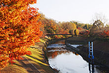
Tatsuta River (Nara Prefectural Tatsuta Park)- Yamato River
- Mount Matsuo
Education[edit]
Elementary schools[edit]
- Ikaruga Elementary School
- Ikarugahigashi Elementary School
- Ikaruganishi Elementary School
Junior high schools[edit]
- Ikaruga Junior High School
- Ikarugaminami Junior High School
High schools[edit]
- Hōryū-ji International High School
Notable places[edit]
Temples and shrines[edit]
- Hōryū-ji
- Hokki-ji
- Hōrin-ji
- Chūgū-ji
- Kichiden-ji
- Mimuroyama
- Ikaruga Shrine
- Ryūta Shrine
Kofun[edit]
- Fujinoki Kofun
- Kasuga Kofun
- Okanohara Kofun
- Terayama Kofun
Transportation[edit]
Rail[edit]
West Japan Railway Company
Kansai Main Line (Yamatoji Line): Hōryūji Station
Road[edit]
 Japan National Route 25
 Japan National Route 168
References[edit]
^ "市町村別推計人口・世帯数". Nara Prefecture. April 1, 2015. Retrieved May 5, 2015..mw-parser-output cite.citationfont-style:inherit.mw-parser-output qquotes:"""""""'""'".mw-parser-output code.cs1-codecolor:inherit;background:inherit;border:inherit;padding:inherit.mw-parser-output .cs1-lock-free abackground:url("//upload.wikimedia.org/wikipedia/commons/thumb/6/65/Lock-green.svg/9px-Lock-green.svg.png")no-repeat;background-position:right .1em center.mw-parser-output .cs1-lock-limited a,.mw-parser-output .cs1-lock-registration abackground:url("//upload.wikimedia.org/wikipedia/commons/thumb/d/d6/Lock-gray-alt-2.svg/9px-Lock-gray-alt-2.svg.png")no-repeat;background-position:right .1em center.mw-parser-output .cs1-lock-subscription abackground:url("//upload.wikimedia.org/wikipedia/commons/thumb/a/aa/Lock-red-alt-2.svg/9px-Lock-red-alt-2.svg.png")no-repeat;background-position:right .1em center.mw-parser-output .cs1-subscription,.mw-parser-output .cs1-registrationcolor:#555.mw-parser-output .cs1-subscription span,.mw-parser-output .cs1-registration spanborder-bottom:1px dotted;cursor:help.mw-parser-output .cs1-hidden-errordisplay:none;font-size:100%.mw-parser-output .cs1-visible-errorfont-size:100%.mw-parser-output .cs1-subscription,.mw-parser-output .cs1-registration,.mw-parser-output .cs1-formatfont-size:95%.mw-parser-output .cs1-kern-left,.mw-parser-output .cs1-kern-wl-leftpadding-left:0.2em.mw-parser-output .cs1-kern-right,.mw-parser-output .cs1-kern-wl-rightpadding-right:0.2em
External links[edit]
| Wikimedia Commons has media related to Ikaruga, Nara. |
Official website (in Japanese)
Nara (capital) | ||
| Core city |
| |
| Cities |
| |
| Districts |
| |
List of mergers in Nara Prefecture | ||
Authority control |
|
|---|
This Nara Prefecture location article is a stub. You can help Wikipedia by expanding it. |
Categories:
- Towns in Nara Prefecture
- Nara geography stubs
(window.RLQ=window.RLQ||).push(function()mw.config.set("wgPageParseReport":"limitreport":"cputime":"1.044","walltime":"1.228","ppvisitednodes":"value":4390,"limit":1000000,"ppgeneratednodes":"value":0,"limit":1500000,"postexpandincludesize":"value":73608,"limit":2097152,"templateargumentsize":"value":19736,"limit":2097152,"expansiondepth":"value":26,"limit":40,"expensivefunctioncount":"value":8,"limit":500,"unstrip-depth":"value":1,"limit":20,"unstrip-size":"value":2683,"limit":5000000,"entityaccesscount":"value":1,"limit":400,"timingprofile":["100.00% 987.341 1 -total"," 51.76% 511.070 1 Template:Infobox_city_Japan"," 49.65% 490.225 1 Template:Infobox_settlement"," 29.38% 290.076 1 Template:Infobox"," 13.84% 136.621 1 Template:Reflist"," 12.53% 123.733 1 Template:Cite_web"," 8.59% 84.850 1 Template:Refimprove"," 6.20% 61.265 9 Template:Both"," 5.68% 56.039 1 Template:Convert"," 5.60% 55.295 1 Template:Coord"],"scribunto":"limitreport-timeusage":"value":"0.416","limit":"10.000","limitreport-memusage":"value":6292479,"limit":52428800,"cachereport":"origin":"mw2164","timestamp":"20181004163714","ttl":1900800,"transientcontent":false);mw.config.set("wgBackendResponseTime":97,"wgHostname":"mw2166"););

 Clash Royale CLAN TAG