Singer railway station
Singer railway station
Jump to navigation
Jump to search
| Singer | |
|---|---|
 | |
| Location | |
| Place | Clydebank |
| Local authority | West Dunbartonshire |
| Coordinates | 55°54′27″N 4°24′20″W / 55.9075°N 4.4055°W / 55.9075; -4.4055Coordinates: 55°54′27″N 4°24′20″W / 55.9075°N 4.4055°W / 55.9075; -4.4055 |
| Grid reference | NS497708 |
| Operations | |
| Station code | SIN |
| Managed by | Abellio ScotRail |
| Number of platforms | 2 |
Live arrivals/departures, station information and onward connections from National Rail Enquiries | |
| Annual rail passenger usage* | |
| 2012/13 | |
| 2013/14 | |
| 2014/15 | |
| 2015/16 | |
| 2016/17 | |
| Passenger Transport Executive | |
| PTE | Strathclyde Partnership for Transport |
| History | |
| Original company | North British Railway |
| Pre-grouping | North British Railway |
| Post-grouping | LNER |
| 3 November 1907 | Opened |
| c.1942 | Singer Workers' Platforms opened |
| 8 May 1967 | Singer Workers' Platforms closed |
National Rail – UK railway stations | |
* Annual estimated passenger usage based on sales of tickets in stated financial year(s) which end or originate at Singer from Office of Rail and Road statistics. Methodology may vary year on year. | |
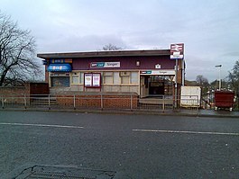
Singer railway station is a two-platformed manned station serving Clydebank town centre, West Dunbartonshire, Scotland. It is located on the Argyle Line, 7 1⁄2 miles (12.1 km) west of Glasgow Central and the North Clyde Line, 8 1⁄2 miles (13.7 km) west of Glasgow Queen Street.
Passenger services are provided by Abellio ScotRail on behalf of Strathclyde Partnership for Transport.
Contents
1 History
2 Services
3 References
4 External links
History[edit]
Singer station took its name from the huge Singer sewing machine factory that it was built to serve.[1][2][3] The station is located on a section of track that was realigned to make space for the factory. In addition to this station (still in use today), the original station, which was titled Singer Works, and previously called Kilbowie Road (Old), once boasted six bay platforms for the many workers' trains that ran there. Regular works trains ended in 1963 and the bay platforms, and indeed the factory, have long since gone.[3][4]
Services[edit]

An Argyle Line service
Singer is served by trains on the half-hourly, all day Monday to Saturdays, on both the Argyle and North Clyde lines. This means Monday to Saturday there is a train every 15 minutes to central Glasgow (alternately to Queen Street L.L. and Central L.L.). Destinations served include Airdrie, Balloch, Dalmuir and Larkhall.[5]
On Sundays, there is a half-hourly service to Glasgow Queen Street served by trains on the North Clyde Line to Edinburgh Waverley and Helensburgh Central.
| Preceding station | Following station | |||
|---|---|---|---|---|
Drumry | | Abellio ScotRail Argyle Line | | Dalmuir |
Drumry | | Abellio ScotRail North Clyde Line | | Dalmuir |
| | Historical railways | | ||
Drumchapel | | North British Railway Glasgow, Dumbarton and Helensburgh Railway | | Dalmuir |
References[edit]
^ "The Clydebank Story - Transport". Retrieved 2008-02-11..mw-parser-output cite.citationfont-style:inherit.mw-parser-output qquotes:"""""""'""'".mw-parser-output code.cs1-codecolor:inherit;background:inherit;border:inherit;padding:inherit.mw-parser-output .cs1-lock-free abackground:url("//upload.wikimedia.org/wikipedia/commons/thumb/6/65/Lock-green.svg/9px-Lock-green.svg.png")no-repeat;background-position:right .1em center.mw-parser-output .cs1-lock-limited a,.mw-parser-output .cs1-lock-registration abackground:url("//upload.wikimedia.org/wikipedia/commons/thumb/d/d6/Lock-gray-alt-2.svg/9px-Lock-gray-alt-2.svg.png")no-repeat;background-position:right .1em center.mw-parser-output .cs1-lock-subscription abackground:url("//upload.wikimedia.org/wikipedia/commons/thumb/a/aa/Lock-red-alt-2.svg/9px-Lock-red-alt-2.svg.png")no-repeat;background-position:right .1em center.mw-parser-output .cs1-subscription,.mw-parser-output .cs1-registrationcolor:#555.mw-parser-output .cs1-subscription span,.mw-parser-output .cs1-registration spanborder-bottom:1px dotted;cursor:help.mw-parser-output .cs1-hidden-errordisplay:none;font-size:100%.mw-parser-output .cs1-visible-errorfont-size:100%.mw-parser-output .cs1-subscription,.mw-parser-output .cs1-registration,.mw-parser-output .cs1-formatfont-size:95%.mw-parser-output .cs1-kern-left,.mw-parser-output .cs1-kern-wl-leftpadding-left:0.2em.mw-parser-output .cs1-kern-right,.mw-parser-output .cs1-kern-wl-rightpadding-right:0.2em
^ McIntosh Gray and Moffat (1989)
^ ab Butt (1995): Page 212
^ "Aerial view of Singer". Archived from the original on 10 February 2008. Retrieved 10 February 2008.
^ GB eNRT May 2016 Edition, Table 226
Butt, R. V. J. (1995). The Directory of Railway Stations: details every public and private passenger station, halt, platform and stopping place, past and present (1st ed.). Sparkford: Patrick Stephens Ltd. ISBN 978-1-85260-508-7. OCLC 60251199.
Jowett, Alan (March 1989). Jowett's Railway Atlas of Great Britain and Ireland: From Pre-Grouping to the Present Day (1st ed.). Sparkford: Patrick Stephens Ltd. ISBN 978-1-85260-086-0. OCLC 22311137.
Yonge, John (May 1987). Gerald Jacobs, ed. British Rail Track Diagams - Book 1: ScotRail (1st ed.). Exeter: Quail Map Company. ISBN 0-9006-0948-6.
Yonge, John (February 1993). Gerald Jacobs, ed. Railway Track Diagams - Book 1: Scotland and the Isle of Man (2nd ed.). Exeter: Quail Map Company. ISBN 0-9006-0995-8.
Yonge, John (April 1996). Gerald Jacobs, ed. Railway Track Diagams - Book 1: Scotland and the Isle of Man (3rd ed.). Exeter: Quail Map Company. ISBN 1-8983-1919-7.
Yonge, John (2007). Gerald Jacobs, ed. Railway Track Diagams - Book 1: Scotland & Isle of Man (Quail Track Plans) (fifth ed.). Bradford on Avon: Trackmaps (formerly Quail Map Co). ISBN 978-0-9549866-3-6. OCLC 79435248.- McIntosh Gray, Alastair and Moffat, William (1989). A History of Scotland. Oxford: Oxford University Press.
ISBN 0-19-917063-0.
External links[edit]
| Wikimedia Commons has media related to Singer railway station. |
- RAILSCOT on Glasgow, Dumbarton and Helensburgh Railway
This Scotland railway station-related article is a stub. You can help Wikipedia by expanding it. |
Categories:
- SPT railway stations
- Railway stations in West Dunbartonshire
- Former North British Railway stations
- Railway stations opened in 1907
- Railway stations served by Abellio ScotRail
- Clydebank
- Scotland railway station stubs
(window.RLQ=window.RLQ||).push(function()mw.config.set("wgPageParseReport":"limitreport":"cputime":"0.492","walltime":"0.610","ppvisitednodes":"value":2902,"limit":1000000,"ppgeneratednodes":"value":0,"limit":1500000,"postexpandincludesize":"value":64223,"limit":2097152,"templateargumentsize":"value":9168,"limit":2097152,"expansiondepth":"value":12,"limit":40,"expensivefunctioncount":"value":3,"limit":500,"unstrip-depth":"value":1,"limit":20,"unstrip-size":"value":16906,"limit":5000000,"entityaccesscount":"value":2,"limit":400,"timingprofile":["100.00% 535.263 1 -total"," 46.54% 249.126 1 Template:Infobox_UK_station"," 44.18% 236.489 1 Template:Infobox"," 24.25% 129.815 2 Template:Rail-interchange"," 13.34% 71.385 1 Template:Reflist"," 11.09% 59.355 2 Template:Cite_web"," 8.82% 47.191 6 Template:Cite_book"," 6.13% 32.805 1 Template:Use_dmy_dates"," 5.29% 28.324 2 Template:Convert"," 5.26% 28.133 1 Template:Coord"],"scribunto":"limitreport-timeusage":"value":"0.170","limit":"10.000","limitreport-memusage":"value":6243180,"limit":52428800,"cachereport":"origin":"mw1245","timestamp":"20181014073554","ttl":1900800,"transientcontent":false);mw.config.set("wgBackendResponseTime":86,"wgHostname":"mw1254"););

 Clash Royale CLAN TAG