北方中央鐵路

 Clash Royale CLAN TAG#URR8PPP
 | 北方中央鐵路(Northern Central Railway) | |
|---|---|
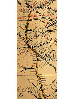
 1863 年的地圖,顯示本路由馬力維爾橋(Marysville Bridge)跨過薩斯奎哈納河。後來路線改行洛克維爾橋(Rockville Bridge)。 | |
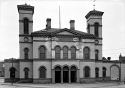
 巴爾的摩的卡伐特車站(Calvert Station),建於1849-50年 | |
| 報告標記 | NCRY |
| 區域 | 賓夕法尼亞州與馬里蘭州 |
| 營運日期 | 1858年–1976年 |
| 前身 | 巴爾的摩與薩斯奎哈納鐵路(Baltimore and Susquehanna Railrod)、約克與馬里蘭鐵路(York and Maryland Line Rail Road)、薩斯奎哈納鐵路(Susquehanna Railroad) |
| 繼承 | 聯合鐵路 |
| 軌距 | 4英尺8 1⁄2英寸(1,435毫米) (標準鐵軌) |
| 线路里程 | 380 英里 (610 公里) [1] |
| 總部 | 巴爾的摩 |
北方中央鐵路(Nothern Central Railway)是美國馬里蘭州巴爾的摩到賓夕法尼亞州森伯里的鐵路,建成於1858年,在1861年被賓州鐵路收購。接下來的110年北方中央鐵路皆在賓州鐵路旗下,直到1972年的一場颶風毀壞了馬里蘭州境內的大部分路線為止。
本鐵路目前已經停業,賓夕法尼亞州至馬里蘭州北部的路段成為步道[2]。巴爾的摩附近的路段則改建為巴爾的摩輕軌。
2013年6月1日起,在賓夕法尼亞州境內漢諾瓦到新自由鎮之間,開始行駛觀光蒸汽火車。[3]

賓州鐵路的「北方中央線」時刻表,1955年。
參考資料
^ Henry Varnum Poor. Poor's Manual of the Railroads of the United States 33. New York: H.V. & H.W. Poor. 1900: 703.
^ Blazing a Trail. Chesapeake Life Magazine. Alter Communications. July 2002 [2008-01-27].Passenger service along the NCR had been curtailed in 1959, but freight service continued until 1972, when Hurricane Agnes swept through the area, destroying much of the track, as well as bridges and culverts.
^ http://steamintohistory.com/
外部連結
- NCRY Annual reports, 1865-1866 (11th-12th), 1869-1910 (15th-56th)
- PRR Corporate History
- PRR Chronology, Chris Baer