File:Desolation-Island-location-map.png
File:Desolation-Island-location-map.png
Jump to navigation
Jump to search
- File
- File history
- File usage
- Global file usage

Size of this preview: 800 × 548 pixels. Other resolutions: 320 × 219 pixels | 640 × 439 pixels | 1,024 × 702 pixels | 1,280 × 877 pixels | 1,669 × 1,144 pixels.
Original file (1,669 × 1,144 pixels, file size: 153 KB, MIME type: image/png)
| This is a file from the Wikimedia Commons. Information from its description page there is shown below. Commons is a freely licensed media file repository. You can help. |
Summary
| DescriptionDesolation-Island-location-map.png | English: Location of Desolation Island in the South Shetland Islands. |
| Date | |
| Source | Own work |
| Author | Apcbg |
Licensing
I, the copyright holder of this work, hereby publish it under the following licenses:
| This file is licensed under the Creative Commons Attribution-Share Alike 3.0 Unported license. | |
https://creativecommons.org/licenses/by-sa/3.0 |
 | Permission is granted to copy, distribute and/or modify this document under the terms of the GNU Free Documentation License, Version 1.2 or any later version published by the Free Software Foundation; with no Invariant Sections, no Front-Cover Texts, and no Back-Cover Texts. A copy of the license is included in the section entitled GNU Free Documentation License.http://www.gnu.org/copyleft/fdl.htmlGFDLGNU Free Documentation Licensetruetrue |
You may select the license of your choice.
File history
Click on a date/time to view the file as it appeared at that time.
| Date/Time | Thumbnail | Dimensions | User | Comment | |
|---|---|---|---|---|---|
| current | 16:48, 24 August 2010 | 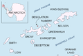 | 1,669 × 1,144 (153 KB) | Apcbg | minor |
| 16:42, 24 August 2010 |  | 1,669 × 1,144 (154 KB) | Apcbg | + location in Antarctica | |
| 14:11, 2 May 2010 |  | 1,669 × 1,144 (5.47 MB) | Apcbg | Source=own Category:Maps of Antarctica |
File usage
The following pages on the English Wikipedia link to this file (pages on other projects are not listed):
- Blythe Bay
- Boynik Point
- Burel Hill
- Cape Danger
- Cora Cove
- Desolation Island (South Shetland Islands)
- Iratais Point
- Kozma Cove
- Miladinovi Islets
- Neck or Nothing Passage
- Wood Island (Livingston Island)
Global file usage
The following other wikis use this file:
- Usage on bg.wikipedia.org
- Иратаис (нос)
- Usage on nn.wikipedia.org
- Craggy Island ved Livingston Island
- Kozma Cove
- Cora Cove
- Blythe Bay
- Cape Danger
- Iratais Point
- Neck or Nothing Passage
- Burel Hill
- Usage on pt.wikipedia.org
- Enseada Kozma
- Usage on zh.wikipedia.org
- 布萊斯灣
- 伊拉塔伊斯角
- 危險岬
- 布雷爾山
- 科茲馬灣
- 科拉灣 (南設得蘭群島)
- 尼克奧納欣水道
(window.RLQ=window.RLQ||).push(function()mw.config.set("wgBackendResponseTime":319,"wgHostname":"mw1247"););