National Register of Historic Places listings in Pender County, North Carolina
National Register of Historic Places listings in Pender County, North Carolina
Jump to navigation
Jump to search

This list includes properties and districts listed on the National Register of Historic Places in Pender County, North Carolina. Click the "Map of all coordinates" link to the right to view an online map of all properties and districts with latitude and longitude coordinates in the table below.[1]
Current listings[edit]
This National Park Service list is complete through NPS recent listings posted December 21, 2018.[2]
| [3] | Name on the Register[4] | Image | Date listed[5] | Location | City or town | Description |
|---|---|---|---|---|---|---|
1 | Gov. Samuel Ashe Grave | October 12, 2001 (#01001096) | Farm Ln., from the southern side of NC 1411, 0.7 miles east of its crossing of Pike Creek 34°28′41″N 77°51′09″W / 34.478056°N 77.8525°W / 34.478056; -77.8525 (Gov. Samuel Ashe Grave) | Rocky Point | ||
2 | Bannerman House | May 31, 1974 (#74001365) | Northeast of Burgaw off NC 53 on NC 1520 34°36′07″N 77°47′26″W / 34.601944°N 77.790556°W / 34.601944; -77.790556 (Bannerman House) | Burgaw | ||
3 | Beatty-Corbett House | March 17, 1986 (#86000549) | NC 701 at NC 1200 34°33′11″N 78°15′09″W / 34.553056°N 78.2525°W / 34.553056; -78.2525 (Beatty-Corbett House) | Ivanhoe | ||
4 | Belvidere Plantation House | June 14, 1982 (#82003495) | Off NC 1565 34°23′05″N 77°38′51″W / 34.384722°N 77.6475°W / 34.384722; -77.6475 (Belvidere Plantation House) | Hampstead | ||
5 | Burgaw Depot | July 24, 1986 (#86001910) | 102 E. Fremont 34°33′00″N 77°55′43″W / 34.55°N 77.928611°W / 34.55; -77.928611 (Burgaw Depot) | Burgaw | ||
6 | Burgaw Historic District | August 27, 1999 (#99001047) | Roughly bounded by Cowan St., Fremont St., Dudley St., and Ashe St. 34°33′05″N 77°55′35″W / 34.551389°N 77.926389°W / 34.551389; -77.926389 (Burgaw Historic District) | Burgaw | ||
7 | Canetuck School | May 31, 2018 (#100002520) | 6098 Canetuck Rd 34°24′43″N 78°12′18″W / 34.4119°N 78.2049°W / 34.4119; -78.2049 (Canetuck School) | Currie vicinity | ||
8 | Cape Fear Civil War Shipwreck Discontiguous District | December 23, 1985 (#85003195) | Address Restricted | Topsail Beach | ||
9 | Moores Creek National Battlefield | October 15, 1966 (#66000070) | 25 miles northwest of Wilmington on NC 210 34°27′27″N 78°06′36″W / 34.4575°N 78.11°W / 34.4575; -78.11 (Moores Creek National Battlefield) | Wilmington | Boundary increased on February 13, 1987, the Moore's Creek National Military Park | |
10 | Pender County Courthouse | May 10, 1979 (#79001741) | Wright, Wilmington, Walker, and Fremont Sts. 34°33′02″N 77°55′34″W / 34.550556°N 77.926111°W / 34.550556; -77.926111 (Pender County Courthouse) | Burgaw | ||
11 | Penderlea Homesteads Historic District | September 27, 2013 (#13000803) | Bounded by Sills Creek and Webber, Crooked Run, Lake, Lamb, and Raccoon Rds. 34°39′34″N 78°02′59″W / 34.659475°N 78.049721°W / 34.659475; -78.049721 (Penderlea Homesteads Historic District) | Willard | ||
12 | Poplar Grove | 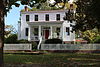 | July 16, 1979 (#79003346) | U.S. Route 17 34°19′13″N 77°45′55″W / 34.320275°N 77.765269°W / 34.320275; -77.765269 (Poplar Grove) | Scotts Hill | |
13 | SS. Peter and Paul's Russian Orthodox Greek Catholic Church | April 17, 2017 (#100000903) | 2384 Front St. 34°30′53″N 77°54′53″W / 34.514670°N 77.914637°W / 34.514670; -77.914637 (SS. Peter and Paul's Russian Orthodox Greek Catholic Church) | St. Helena | ||
14 | Sloop Point | January 20, 1972 (#72000985) | Northeast of Vista off NC 1561 34°24′58″N 77°35′55″W / 34.416111°N 77.598611°W / 34.416111; -77.598611 (Sloop Point) | Vista | ||
15 | US Naval Ordnance Testing Facility Assembly Building |  | September 14, 1993 (#93000909) | Junction of Channel Boulevard and Flake Ave. 34°22′02″N 77°37′49″W / 34.367222°N 77.630278°W / 34.367222; -77.630278 (US Naval Ordnance Testing Facility Assembly Building) | Topsail Beach | |
16 | US Naval Ordnance Testing Facility Control Tower |  | September 14, 1993 (#93000910) | Southwestern corner of S. Anderson Boulevard and Flake Ave. 34°21′58″N 77°37′45″W / 34.366111°N 77.629167°W / 34.366111; -77.629167 (US Naval Ordnance Testing Facility Control Tower) | Topsail Beach | |
17 | US Naval Ordnance Testing Facility Observation Tower No. 2 |  | September 14, 1993 (#93000911) | 1000 block of S. Anderson Boulevard 34°22′53″N 77°36′47″W / 34.381389°N 77.613056°W / 34.381389; -77.613056 (US Naval Ordnance Testing Facility Observation Tower No. 2) | Topsail Beach |
See also[edit]
| Wikimedia Commons has media related to National Register of Historic Places in Pender County, North Carolina. |
- National Register of Historic Places listings in North Carolina
- List of National Historic Landmarks in North Carolina
References[edit]
^ The latitude and longitude information provided in this table was derived originally from the National Register Information System, which has been found to be fairly accurate for about 99% of listings. For about 1% of NRIS original coordinates, experience has shown that one or both coordinates are typos or otherwise extremely far off; some corrections may have been made. A more subtle problem causes many locations to be off by up to 150 yards, depending on location in the country: most NRIS coordinates were derived from tracing out latitude and longitudes from USGS topographical quadrant maps created under the North American Datum of 1927, which differs from the current, highly accurate WGS84 GPS system used by most on-line maps. Chicago is about right, but NRIS longitudes in Washington are higher by about 4.5 seconds, and are lower by about 2.0 seconds in Maine. Latitudes differ by about 1.0 second in Florida. Some locations in this table may have been corrected to current GPS standards.
^ "National Register of Historic Places: Weekly List Actions". National Park Service, United States Department of the Interior. Retrieved on December 21, 2018.
^ Numbers represent an ordering by significant words. Various colorings, defined here, differentiate National Historic Landmarks and historic districts from other NRHP buildings, structures, sites or objects.
^ National Park Service (2008-04-24). "National Register Information System". National Register of Historic Places. National Park Service..mw-parser-output cite.citationfont-style:inherit.mw-parser-output qquotes:"""""""'""'".mw-parser-output code.cs1-codecolor:inherit;background:inherit;border:inherit;padding:inherit.mw-parser-output .cs1-lock-free abackground:url("//upload.wikimedia.org/wikipedia/commons/thumb/6/65/Lock-green.svg/9px-Lock-green.svg.png")no-repeat;background-position:right .1em center.mw-parser-output .cs1-lock-limited a,.mw-parser-output .cs1-lock-registration abackground:url("//upload.wikimedia.org/wikipedia/commons/thumb/d/d6/Lock-gray-alt-2.svg/9px-Lock-gray-alt-2.svg.png")no-repeat;background-position:right .1em center.mw-parser-output .cs1-lock-subscription abackground:url("//upload.wikimedia.org/wikipedia/commons/thumb/a/aa/Lock-red-alt-2.svg/9px-Lock-red-alt-2.svg.png")no-repeat;background-position:right .1em center.mw-parser-output .cs1-subscription,.mw-parser-output .cs1-registrationcolor:#555.mw-parser-output .cs1-subscription span,.mw-parser-output .cs1-registration spanborder-bottom:1px dotted;cursor:help.mw-parser-output .cs1-hidden-errordisplay:none;font-size:100%.mw-parser-output .cs1-visible-errorfont-size:100%.mw-parser-output .cs1-subscription,.mw-parser-output .cs1-registration,.mw-parser-output .cs1-formatfont-size:95%.mw-parser-output .cs1-kern-left,.mw-parser-output .cs1-kern-wl-leftpadding-left:0.2em.mw-parser-output .cs1-kern-right,.mw-parser-output .cs1-kern-wl-rightpadding-right:0.2em
^ The eight-digit number below each date is the number assigned to each location in the National Register Information System database, which can be viewed by clicking the number.
U.S. National Register of Historic Places in North Carolina | ||
|---|---|---|
| Topics |
|   |
| Lists by county |
| |
| Other lists |
| |
U.S. National Register of Historic Places | |
|---|---|
| Topics |
|
| Lists by states |
|
| Lists by insular areas |
|
| Lists by associated states |
|
| Other areas |
|
| |
Municipalities and communities of Pender County, North Carolina, United States | ||
|---|---|---|
County seat: Burgaw | ||
| Towns |
|  |
| Village |
| |
| CDPs |
| |
| Unincorporated communities |
| |
| Footnotes | ‡This populated place also has portions in an adjacent county or counties | |
Categories:
- Pender County, North Carolina
- Lists of National Register of Historic Places in North Carolina by county
- National Register of Historic Places in Pender County, North Carolina
(window.RLQ=window.RLQ||).push(function()mw.config.set("wgPageParseReport":"limitreport":"cputime":"0.532","walltime":"0.656","ppvisitednodes":"value":7751,"limit":1000000,"ppgeneratednodes":"value":0,"limit":1500000,"postexpandincludesize":"value":183716,"limit":2097152,"templateargumentsize":"value":10930,"limit":2097152,"expansiondepth":"value":11,"limit":40,"expensivefunctioncount":"value":0,"limit":500,"unstrip-depth":"value":1,"limit":20,"unstrip-size":"value":5545,"limit":5000000,"entityaccesscount":"value":0,"limit":400,"timingprofile":["100.00% 506.402 1 -total"," 43.53% 220.436 17 Template:NRHP_row"," 22.96% 116.286 1 Template:NRHP_header"," 18.72% 94.775 1 Template:NRISref"," 17.98% 91.050 1 Template:Cite_web"," 11.98% 60.684 1 Template:Commons_category"," 11.46% 58.048 46 Template:First_word"," 9.12% 46.187 3 Template:Navbox"," 8.60% 43.574 16 Template:Coord"," 8.24% 41.731 18 Template:Designation/color"],"scribunto":"limitreport-timeusage":"value":"0.193","limit":"10.000","limitreport-memusage":"value":3675488,"limit":52428800,"cachereport":"origin":"mw1303","timestamp":"20181228024528","ttl":1900800,"transientcontent":false););"@context":"https://schema.org","@type":"Article","name":"National Register of Historic Places listings in Pender County, North Carolina","url":"https://en.wikipedia.org/wiki/National_Register_of_Historic_Places_listings_in_Pender_County,_North_Carolina","sameAs":"http://www.wikidata.org/entity/Q6977157","mainEntity":"http://www.wikidata.org/entity/Q6977157","author":"@type":"Organization","name":"Contributors to Wikimedia projects","publisher":"@type":"Organization","name":"Wikimedia Foundation, Inc.","logo":"@type":"ImageObject","url":"https://www.wikimedia.org/static/images/wmf-hor-googpub.png","datePublished":"2009-07-13T04:22:09Z","dateModified":"2018-06-12T01:48:45Z","image":"https://upload.wikimedia.org/wikipedia/commons/4/49/North_Carolina_Map_Highlighting_Pender_County.PNG","headline":"Wikimedia list article"(window.RLQ=window.RLQ||).push(function()mw.config.set("wgBackendResponseTime":89,"wgHostname":"mw1270"););

 Clash Royale CLAN TAG